Round Valley Hike
Round Valley hike | Mt. San Jacinto Wilderness Hiking
Round Valley: A hike of about 2.5 miles one way that leads to picturesque Round Valley. Fairly level trails, short climbs, moderately strenuous. You can also hike the Round Valley loop which is a moderately strenuous hike of about 5 miles. As you leave the Long Valley Ranger Station you will see the sign that points you in the direction of most of the hikes, including the loop trail. The loop trail is easiest if you follow the trail to the right when you get to the sign behind the ranger station. The way to the left starts to climb almost immediately and is more difficult.
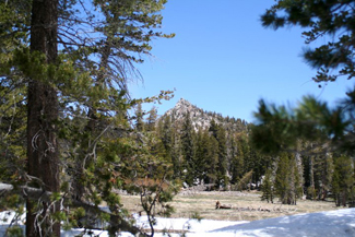
This is one of my favorite hikes at the tram. The Round Valley hike which starts at the mountain station of the Palm Springs Aerial Tramway, and takes you past cool mountain streams, and beautiful mountain scenery.
To begin the hike you will take the ramp down from the mountain station to the Long Valley Ranger Station. The hike takes you through part of the Mt. San Jacinto Wilderness, so you will have to stop at the ranger station to pick up your free wilderness permit. After obtaining your permit, and asking the ranger about current trail conditions, you will follow the trail that leads from the left side of the ranger station up the hill. After a short while you will come to a 'Y' in the trail. You can get to Round Valley either way, however the trail to the right is a more gradual uphill climb than the trail to the left. The choice is yours at that point.
Either way you go there are signs along the trail to point you in the right direction, but if it is your first visit I recommend purchasing a trail map from the gift store at the mountain station of the tram.
If you take the trail to the right like I usually do, it is a fairly level hike in some places, with some short climbs through switchbacks, and it is a moderately strenuous hike of about 2.5 miles one way that leads to picturesque Round Valley.
Along the way you will past through a few meadows which during the summer are filled with lush vegetation, including the beautiful corn lily, which begins to sprout early late in May or early June, and by July is blooming with beautiful flowers at the top of the plant.
You will also have the chance to possibly view some of the wildlife in the area, including squirrels, deer, bobcats and other species.
Less than half a mile from Round Valley you will come to a junction in the trail, if you go to the left you will continue on what is called the Round Valley Loop, and that will take you back to the ranger station. If you go right you will reach Round Valley itself.
Once at Round Valley you can stop and have a snack while enjoying the fresh mountain air, blue skies and the quiet of the wilderness.
If you are planning on hiking further, to Wellmans Divide or the peak of Mt. San Jacinto there are signs in Round Valley to point the way.
When you are ready to return to the ranger station you can return the way you came, or continue along the Round Valley Loop at the junction a short ways from Round Valley that you came across on the way there. If you return the way you came it will be mostly a downhill hike from that point, however if you take the other section of the loop trail you will have some uphill climbing to do on the way back.
Please remember that this hike is in a wilderness location, so you should always check the weather reports before going up the mountain, or ask the ranger about any possible storms coming your way, and always have proper hiking equipment. You should have proper hiking boots or shoes, and plenty of water and follow these hiking tips.
Round Valley Hike Photo Gallery
![]() Photo gallery of the Round Valley Hike from June of 2011
Photo gallery of the Round Valley Hike from June of 2011
Round Valley Loop Photo Gallery
![]() Photo gallery of the Round Valley Loop Hike from July of 2011
Photo gallery of the Round Valley Loop Hike from July of 2011
Click here for more trails to hike at the Palm Springs Aerial Tramway
The Palm Springs Aerial Tramway takes you up to Mt. San Jacinto State Park which offers about 54 miles of hiking trails located within the 14,000 acre Mt. San Jacinto Wilderness area. All of the trails including the trail to Round Valley are accessed by exiting the Mountain Station and descending a concrete pathway less than a mile lont to Long Valley.
Palm Springs Aerial Tramway Photo Gallery
![]() View photo gallery of the tram from May 2011
View photo gallery of the tram from May 2011
|
Palm Springs Trail GuideThis is by far the best guide to hiking in the Palm Springs area! |
Mount San Jacinto State Park Information
- Mount San Jacinto State Park Homepage
- 10-day Idyllwild Weather Forecast
Address: 25905 Highway 243, Idyllwild, CA 92549
Mt. San Jacinto Message Board
Planning on hiking up Mt. San Jacinto? Here is a great website to find out current trail conditions, weather and to meet up with other hikers.
- Mt. San Jacinto Message Board
Weather Conditions at The Palm Springs Aerial Tramway
Check the weather conditions at top of the Tram before going on any hike in the Mt. San Jacinto Wilderness. Even in the summer storms can pass through which can make hiking dangerous. During the winter knowing if a storm is coming can save your life. Click here for weather conditions at top of the Palm Springs Aerial Tramway.
Please use caution hikers!
Hiking in and around Palm Springs and at the top of the tram in the Mt. San Jacinto Wilderness can be very dangerous, and many people have to be rescued from the area at the top of the tram each year. Usually it is due to lack of preparation, such as having proper hiking equipment, pleanty of water and also a map of the area. Just because it is a desert doesn't mean it will not get cold in the winter, and it definitely gets very hot in the summer. Weather at the top of the Palm Springs Aerial Tramway can be hot in the summer, and very cold in the winter, and it can be windy and very dangerous. Wear proper clothing, have proper equipment and follow these hiking tips or you may pay with your life.
Also, please stay on the trails. There is no reason to get lost in this area if you stay on the trails and use common sense.
Hiking Books For Palm Springs
Philip Ferranti's books on hiking in Palm Springs, the Coachella Valley and surrounding areas are a must have if you are planning on hiking in the area. Amazon.com also has several other books that will make your hiking adventure a great one, including books on hiking and rock climbing in Joshua Tree National Park.
Click the hikers for Hiking Tips
![]()
![]()
![]()
For tips on how much WATER you need click above
Hiking In Palm Springs Disclaimer
Any outdoor recreation can be potentially hazardous, and hiking is no exception. All participants must assume responsibility for their own actions and safety, exercise sound judgment, and be prepared for and seek advice on weather and trail conditions.
Although the authors and publisher of Hiking-in-ps.com ("this site") try to make the site as accurate as possible, they disclaim any liability for accident, loss, injury, inconvenience or other damage that may be sustained by anyone using the information contained on the site.